34 / 62
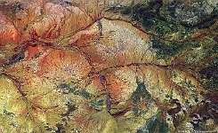
Hope River, Australia
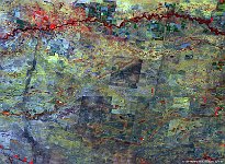
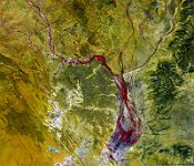
The mid-west of Western Australia state, occupying one third of Australia, is only sparsely populated, with mining and pastoralism in large ranches as main economic activities. In this arid region, shown in the false-colour image of late June 2015, the last part of Hope river flows northwestward to join the Yalgar river (east-west oriented, middle of the image) and subsequently the Murchison river that will discharge into the Indian Ocean further southwest. At 100 m spatial resolution, we can see the impressive network of small rivers and creeks. Together, the Murchison-Yalgar-Hope river system is the longest river system of Western Australia.
As the rain that feeds this system is generally linked to Summer cyclones, the Murchison river does not flow much of the year, resulting in a dry, sandy river bed. The cyclones do cause occasional flooding, such as the record-high flow in 2006.
Date: 25/06/2015
Resolution: 100m
