17 / 62
Bangladesh, Asia
One of the climate change implications is global sea level rise, with Bangladesh as one of the most vulnerable countries.
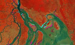
The 100 m image above of the Ganges-Brahmaputra delta (27 February 2017) is overlaid by a map that indicates the land (in purple) and water (in light blue) gained between March 2014 and February 2017. The observed land and water distribution change cannot be attributed to climate change solely, but also to natural delta dynamics, resulting in an interplay between river sedimentation and erosion. Nevertheless, between 2014 and 2017 an estimated net 15 km2 of land was claimed by the ocean. More information on the land-sea detection methodology and PROBA-V’s role in global sea level rise monitoring can be found in our Remote Sensing blog. https://blog.vito.be/remotesensing/monitoring-global-sea-level-rise-using-satellite-data
Date: 27/02/2017
Resolution: 100m
