30 / 52
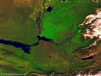
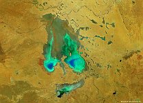
Chardara reservoir & Aydar Lake
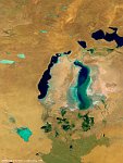
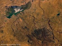
The 100 m false-colour image of 6 March 2016 shows us (at left) Lake Aydarkul, part of the man-made Aydar-Arnasay system of lakes, which covers an area of 4,000 square kilometres. This system includes 3 brackish water lakes (Aydar Kul, Arnasay and Tuzkan) located in the saline depressions of the south-eastern Kyzyl Kum (now in Uzbekistan and Kazakhstan). In the early sixties the Syr Darya was dammed up. Simultaneously the Chardarya irrigation dam was constructed (light spot in the middle). Floodgates were provided in the dam for flood control, and when in 1969 a raging flood occurred, these were opened as the dam's capacity was inadequate to cope with the flow. Between February 1969 and February 1970 almost 60% of the Syr Darya's average annual water flow (21 km³) was drained from the Chardarya Reservoir (lake in middle of the image) into the Arnasay lowland. In such a way new lakes were unintentionally created. Since 1969 the Aydar Lake has regularly received the waters of the Syr Darya River when they overflow the capacity of the Chardarya Reservoir. This has gradually filled up the natural cavity of Arnasay lowland to create the second largest lake in the region (after the remains of the Aral Sea).
Date: 06/03/2016
Resolution: 100m
